A sea breeze occurs when the solar radiation from the sun heats up the land a lot more than a nearby body of water due to water's high heat capacity, or resistance to absorbing heat quickly. The air near the ground heats up, becomes less dense and thus rises. Because there can't be a vacuum, air rushes in to take its place, which happens to be the cooler, more dense air from above the sea. This circulation doesn't always stay confined to the shore and can infact move inland. The Long Island Sea Breeze can sweep cool air from the Atlantic Ocean across the entire island and may even meet and converge with a Long Island Sound Breeze coming in from the north.
Missions #2 and #3 of the DREAMS Project focused on measuring the environment of the sea breeze. Weak west-southwesterly winds from a high pressure system to our northeast set up a favorable pattern for sea breeze development on both June 20th and 21st. A description of both missions is provided.
 |
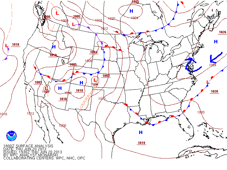
| 18Z (2 PM) surface analysis from the Weather Prediction Center showing a high pressure system to our northeast with anticyclonic (clockwise) flow around it. |
Mission #2: Sea Breeze Interception
 |
| The pod that was deployed. |
The goal of the mission on Thursday, June 20th was to capture the full evolution of the sea breeze as it made its way from the South Shore to the North Shore. The plan was to station the DOW at a point along the South Shore and measure the boundary until it went "out of sight" at which time the DOW would be re-positioned to a more northern location. Students would take surface measurements with hand-held instruments to try to keep tabs on its movement. William Floyd Parkway provided the perfect north-south route for this mission. The students and the DOW arrived at Smith Point Beach in Mastic Beach at 9 AM. A pod was deployed at dune-level to take surface measurements of the onshore flow. Students worked with the DOW to measure the boundary that indicated the northward advancement of the sea breeze by looking at reflectivity and velocity data.
 |
Map showing locations of students and the DOW.
|
A car of students was sent northward along William Floyd Parkway with
hand-held instruments to fill-in some data-sparse regions that were
lacking surface observations and also to look for surface-based evidence
that there was a boundary. They measured temperature, dew point, relative humidity, wind speed (averaged and maximum gust), and wind direction. There were two extra soundings launched from the National Weather Service (NWS) Forecast Office at Upton. One at around 15Z (11 AM) and one around (18Z) 2 PM. A faculty member, John Mak, from the School of Marine and Atmospheric Sciences at SBU flew his research aircraft in the afternoon right over Smith Point that took measurements of the environment including temperature, relative humidity, pressure, 3-dimensional winds. He completed spirals to procure a vertical profile of these quantities at Smith Point and Brookhaven Airport and flew transects through the boundary layer from over the ocean towards land. I don't think John was measured by the DOW, but that would be interesting!
At around 1 PM, the DOW relocated to Enterprise Park at Calverton (EPCAL) where it set up near the north entrance. There were plenty of cumulus in the sky showing where the convergence of the low-level winds along the sea breeze were causing rising motion. There was no measurable rain associated with these clouds, so this was a very quiet sea breeze event. Not as quiet as Mission #3 as you'll soon discover.
 |
| DOW on Nicolls Rd. |
Mission #3: Sea Breeze Part II
Not wanting to waste a day with the DOW in town, the forecast for Friday, June 21st showed the possibility of another sea breeze development. The decision was to station the DOW at one location and let the sea breeze come to it. That location was chosen to be at EPCAL so that the data can be compared with that of the previous day. The DOW left Stony Brook University at 9:15 AM and headed east to EPCAL. It set up at the North Entrance and students prepared the pod to take surface measurements and took their own measurements with hand-held instruments to compare. A team of students left the site to travel south along William Floyd (in a car marked with "sea breeze interceptor" in paint on the window!) to take surface measurements and look for signs of the boundary.
By 1 PM EDT, the students were getting excited over the slightest tiny developing cumulus cloud. There were not a lot of clouds along this boundary even though the data being collected by the DOW showed a clear wind shift and higher reflectivity values.
 |
| The DOW with a tiny cumulus. |
There was clearly enough "stuff" in the atmosphere to scatter back radiation to the DOW to be measured but not enough moisture to produce clouds for our naked eyes to see. For the sake of comparison, a team of students launched an extra weather balloon at the NWS and John Mak flew his aircraft to take measurements of the environment. The obvious question is that even though both of these sea breeze boundaries were "quiet", why was one so much "quieter" than the other? If one looks at each day's 12Z (8 AM) soundings, the environment looks very similar.
 |
| 12Z soundings for June 20 (left) and 21 (right). |
The data collected have not started to be analyzed yet, but the short answer is a difference in low-level moisture between the two days. The air near the surface is converging and rising, so the nature of that air will determine if there will be developing clouds (among other things). The air near the surface on the drier day (June 21st/Mission #3) has a lower dew point and a higher surface temperature. Another factor is that the air aloft is drier too which can be told by the distance between the red temperature line and the green dew point line.
No storms fired up along the sea breeze boundaries because there was a large area of high pressure dominating the region and causing the atmosphere to be stable, or resistant, to upward vertical motion. The sea breezes, although they were measured and are very interesting, were a bit on the weak side. This is the nature of field work, however, so it is important for the students to experience first-hand how the atmosphere doesn't always provide exactly what you are looking to measure. Hopefully the missions completed during the second week with the DOW are a lot more exciting! Stay tuned!
- For more information on sea breezes, please visit this site:
http://www.srh.noaa.gov/jetstream/ocean/seabreezes.htm
- For near-realtime updates on the DREAMS Project, please visit this site:
http://dreamsproject.weebly.com/schedule.html


No comments:
Post a Comment