The DREAMS Project started its second week with a mission, to keep the DOW busy of course! The forecast for Monday, June 24 called for a slight chance of scattered severe thunderstorms in the New York City vicinity and an enhancement of the New York Bight Jet. Thunderstorms sound exciting but you may ask,
"What exactly is the New York Bight Jet?" The New York Bight Jet is an interesting coastal phenomenon that involves low-level winds, as the word "jet" implies. When there is synoptic (or large-scale) southwesterly winds, the winds near the surface just east off the coast of New Jersey can become enhanced south of Long Island. The winds become enhanced because of processes that are similar to a large-scale sea breeze (see the previous post for more about sea breezes), or simply stemming from the idea that the land is heated a lot more than the adjacent ocean water. The DOW team of students and faculty set out to Rockaway, NY to set up at Jacob Riis Beach to catch all the action.
Although the NY Bight Jet was not measured with the DOW to be as strong, or enhanced, as it was forecast to be, the team stationed at Jacob Riis Beach successfully captured some convection that fired up along the smaller-scale Long Island sea breeze. They happened to be in the right place at the right time.
The region was placed under a "slight risk" for severe weather by the Storm Prediction Center for that day. Conditions were ripe for convection. The 12Z (8 AM) sounding from the NWS NYC Office showed that
 |
| 12Z (8 AM) Upton, NY Sounding for June 24. |
although there was a near-surface inversion (temperatures rising with height which causes resistance to the rapid rising of air), the gradual warming of the surface temperature due to solar insolation should allow for the values of CAPE (Convective Available Potential Energy, from the post for Mission #1, remember?) to increase and allow for the development of convection. Recall from that post on the embedded convection of Mission #1 that in order to have thunderstorms you need three ingredients: moisture, instability, and lift. From the morning's sounding, there was plenty of moisture throughout the low to mid-levels of the atmosphere, but what about lift?
 |
| Snapshot at 18Z (2 PM) of the near-surface convergence. |
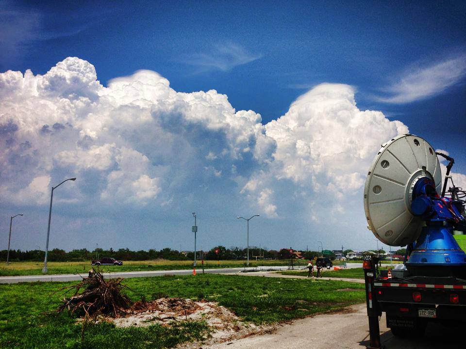
The Long Island sea breeze ended up providing the necessary lifting mechanism for the storms to fire up. When the westerly flow converged with the southerly flow near the Queens/Nassau border, thunderstorms formed and a severe thunderstorm warning was even issued by the NWS around 1:30 PM EDT. Because the DOW was situated at Jacob Riis Beach, they could watch the storms from a safe distance and collect horizontal and vertical slices of radar reflectivity and velocity.
 |
| A photo of the storms from Jacob Riis Beach taken by a member of the DOW field group. |
The New York Bight Jet was measured to have formed after the excitement of the early-afternoon convection wore off. Therefore, Mission #4 was a success and provided a great dataset of the Bight Jet and convection over Western Long Island. After driving the DOW about 2 hours away from Stony Brook University, I think it is safe to say that it was well worth the trip. If you missed the DOW's visit to Rockaway on Monday, June 24, you may see us again soon! It's a great location with a great "view" that we hope to use again.


No comments:
Post a Comment