Thursday, February 27, 2014

A Tale of Two Days of Snow Showers

You are late to leave your house and are hustling around to grab your bag and car keys and once you walk outside of your front door you see... it's snowing?! Why is it snowing? They didn't say it would snow. I don't have any bread and milk! As similar thoughts run through your mind as you start your car and back out of your driveway, the sun comes out. Oh, that's all? Wow, I give up on the weather. Don't give up! There's a great explanation for why for the past two days (Wednesday, February 26th and Thursday, February 27th) there have been lines or cells of snow showers flowing across our area.

These snow showers have been the result of the clashing of air masses in a smaller way than producing a large, coastal cyclone as has been discussed in previous posts on major snowbands. That's why they are so transient, or move through quickly without too much accumulation or disruption of travel. However, they are capable of quickly dumping over an inch of snow and causing dangerously decreased visibility while driving. These snow showers can form as a result of surface forcing from cold air pushing warm air up and over it which condenses any water vapor into clouds which can precipitate. They can also form as a result of upper-level forcing which means that the air's motion high up in the atmosphere can actually cause air at the surface to rise and any water vapor condenses into clouds which can precipitate. Most times, it's a bit of both mechanisms.

So what was up with the snow showers on both February 26th and 27th? They were similar but also a little bit different, as I'll explain.

A Tale of Two Days of Snow Showers

A very cold air mass has been creeping down into the Northeast from Canada and with it have been several fronts, or boundaries, of cold air making its advance towards our region. The image below shows a surface map for Wednesday, February 26th with a deep low pressure center north of the Great Lakes indicating that there's cold air in place and a weaker low pressure center in Quebec north of New York with a cold front draped off the coast. The cold air behind this front and the fact that there was some help at upper-levels of the atmosphere acted to organize some lines of snow showers on this day.

NOAA/NWS Weather Prediction Center Surface Analysis and Radar for 2100Z 26 Feb (4 PM).

Things were slightly different for Thursday, February 27th, however. That strong low pressure center and much colder air has made its way east and its the cold front associated with this that at 1 PM EST was analyzed to be stretching southward through Central New York and Pennsylvania that, combined with some favorable conditions at low-levels and upper-level forcing acted to organize some cells of snow showers across our area in the mid-afternoon.

NOAA/NWS Weather Prediction Center Surface Analysis and Radar for 1800Z 27 Feb (1 PM).

The Wednesday, Feb. 26th snow showers were post-frontal when there was cold air advection (the wind blows colder air into the area) within the lower portion of the atmosphere. The Thursday, Feb. 27th snow showers were pre-frontal when there was warm air advection (the wind blows warmer air into the area) within the lower portion of the atmosphere. To look into this in more depth, the Stony Brook University-Weather Research and Forecasting (SBU-WRF) model was used to plot some variables which are operationally available to the public at the following website. The use of a weather model in a forecasting sense is also proof that these snow showers were predictable even though they were on such a small scale. The plots below show a slice of the atmosphere near the surface with temperatures shaded with the cooler colors indicating cold temperatures and the warmer colors indicating warm temperatures (can we go to Florida now, please?!) with Wednesday on the left and Thursday on the right. Notice first how much colder the air mass over the upper Great Plains has gotten over the course of a day. Notice second how within our box there is a transition, or gradient, between colder air and warmer air with colder air being to our northwest and warmer air to our southeast. It's hard to tell but the winds within this box show the advection at this level, or the transport of air of a certain temperature into the region. On Wednesday, winds are mostly blowing from the northwest ushering in colder air. While on Thursday, winds are mostly blowing from the west-southwest which is actually ushering in a little bit of "warmer" air ahead of the air mass boundary.


Left: Wednesday, February 26th at 3 PM and Right: Thursday, February 27th at 12 PM showing 925 mb temperatures shaded and a box highlighting our region.

This pattern of cold air and warm air advection can be seen be plotting a time series of temperature and wind direction at a location at the surface. Here's the model forecast time series plots for Stony Brook University. When the winds are directed more from the north (indicated by the barbs that are pointing into the wind pointed more towards the northwest on the bottom plot) then there is colder air being brought to the station and the temperatures decrease. The reverse is true for when the winds blow more from the south or southwest which corresponds to warm air advection and the temperature increases.


SBU-WRF 12Z GFS 26 Feb Model Time Series of temperature/dew point temperature on the top and wind speed and direction (indicated by the barbs pointing into the wind). The blue boxes and ovals show times of cold air advection and the red ovals/pink box show times of warm air advection.

The fact that the air mass can change at different levels of the atmosphere (low, middle and high) can help air rise or sink. For example, when there's warm air advection in the lower part of the atmosphere, this may cause that air the be unstable and it will rise until it cools off to the average temperature of the rest of the air mass. Conversely, if there is cold air advection at mid-levels, air will want to sink until it will warm to the average temperature of the rest of the air mass. The result of the cold advection on Wednesday versus the warm advection on Thursday was that the snow showers were organized a bit differently across Long Island.

The following images show observed (left plot) and modeled (right plot) of radar reflectivity of the snow showers from the NWS/New York Radar.

Observed (left) and modeled (right) base radar reflectivity at 1700Z (12 PM EST).

The above image is for the Wednesday snow showers which shows heavier precipitation to the southwest associated with the cold front but smaller banded snow showers with the same orientation as the cold front but much smaller and weaker. These are likely resulting from some forcing at upper levels of the atmosphere related to cold frontal structure.


Observed (left) and modeled (right) base radar reflectivity for 3 PM EST.

The above image is for Thursday's snow showers. Notice how there are scattered, cellular snow showers found just east of Long Island whereas there are more linear features found across Central New York (upper-left portion of box in the observed and upper-left of model area). The linear feature is associated with the surface-based cold front, however the warm air advection out ahead of it as previously discussed allowed there to be favorable conditions for sporadic rising air which combined with the forcing at upper-levels of the atmosphere led to some snow showers. The Health Sciences Center (HSC) at Stony Brook University as weather instrumentation complete with a camera which is useful in capturing events like this. Check out the image below for a snapshot from 3 PM EST Thursday.


Snapshot from HSC camera showing the back-end of some of the snow-producing clouds at 3 PM EST.

So the moral of the story, or the tale of two days of snow showers, is that not every snowflake that is seen falling to the ground spells doom for Long Island. We are capable of getting weak snowfalls just as we are capable of getting crippling nor'easters, given the right air masses. While the mechanics behind these snow showers can be different and a little complicated, it's nice to experience them because it's similar to the type of precipitation structure we'd experience during the warmer seasons but loads cooler because there's snow falling! Maybe it's just that I'm super into snow, but I'd much rather get snowed on while walking unprepared to my car than get drenched by rain. Enjoy the snow while it lasts this winter season!

Monday, January 20, 2014

Snowbands & Why They Love Long Island

If you've ever experienced a coastal winter storm while living on Long Island or the surrounding Metro area then you've likely seen the following evolution: A forecast comes out calling for a little bit of snow in the next few days which incites little panic among the public. The day before the snowstorm the forecast changes because there had been a lot of model uncertainty and suddenly the forecast snow totals are a lot higher and panic ensues! (Cue bread and milk chaos!) The storm causes numerous traffic problems including airport and even highway closures throughout the Tri-state area. The snowstorm ends and it turns out that your buddy a few towns over got a ton more snow than you did. What gives? The forecast snow totals were correct, but for your buddy and not for you. Some examples include the February Blizzard of 2013, "Snowmageddon" of December 26-27 2010, among many others. This scenario rings some bells, right? Let's get to the bottom of it.

Long Island is jutting right out into the storm track that is very active during the cool season months, i.e. October - March where coastal lows tend to develop after upper-atmospheric energy is transferred from the west over the Appalachian Mountains and interacts with the existing temperature gradient (baroclinic zone) that is in place at the coast sandwiched between the cold, continental air over the Eastern U.S. and the warm, moist air over the Western Atlantic Ocean fed by the Gulf Stream.

North American Storm Tracks (Source: Understanding Weather and Climate, 6th ed. by Aguado & Burt)
Once a coastal low forms, it usually strengthens and moves northeastward along the coast up towards New England. The broad area of precipiation that is usually light in nature can organize itself into narrow areas of intense snowfall, known as a snowband. A snowband can be a few miles wide and a few tens to about a hundred miles long-- and like most things they come in a lot of different shapes and sizes. When a coastal low forms, there is typically warm air to the southeast of it and cold air to the northwest of its center. Air moves in a cyclonic or counterclockwise direction which acts to create fronts, or boundaries between the distinct air masses. A snowband that is set to impact Long Island typically forms north of the warm front where warm, moist air is ascending over a wall of colder, more dense air. As the low strengthens, this warm air is vigorously churned counterclockwise towards the west and the snowband pivots to the northwest of the surface cyclone center. As the low matures the snowband can sometimes be found to the west of the surface cyclone center. You can see the positions of the snowband relative to the surface low in the following schematic:

The recipe for a very strong snowband includes strong winds clashing together to the northwest of a low pressure center that extends a few miles up into the atmosphere, sufficient moisture so that there is plenty of water vapor to condense into clouds and provide a lot of precipitation, and just like with summertime thunderstorms there should be a little bit of instability or a region of air in which a pocket of air will be less dense and able to rise rapidly. A lot of research has been completed investigating these snowbands and a Stony Brook University alumnus, David Novak, published many peer-reviewed papers about those that occur in the Northeast. He looked at many storms and determined the general ingredients needed to cook up a great snowband as summarized in the following figure.

The ingredients for a mesoscale snowband modified from Novak et al. 2004.
The two locations highlighted by the stars indicate the preferred locations for snowbands. In the red shading are regions of frontogenesis, or the creation (i.e. genesis) of fronts or the clashing of two air masses. The region enveloped in a scalloped line shows a region of deformation or where the winds have a component that are converging which enhances frontogenesis. While there may be snow all around the surface low for miles and miles it shouldn't be as heavy as within the regions of snowbands indicated by those stars-- all thanks to frontogenesis. Let's talk more about frontogenesis and not just because it's a really fun word to say.

Frontogenesis, or the formation of fronts, means that the atmosphere is unbalanced. The fact that there is a temperature gradient (that's what a front is) means that the atmosphere is a bit unstable and wants to even out that temperature gradient. How can it create a uniform temperature distribution if it has to fight against the really strong horizontal winds that keep making the temperature gradient stronger? To combat the imbalance, the atmosphere initiates a vertical wind circulation because when you can't go out you go up, right? The atmosphere induces a frontogenetical circulation that causes warm air to rise and cool on the warm side of the front (cooling down the warmer air) and cold air to descend and warm on the cold side of the front (warming up the colder air). This warm, rising air is usually incredibly moist so there's plenty of water vapor to create deep clouds that produce heavy snow and with that the snowband is formed. This circulation is usually very small because the temperature gradient at the front itself is very narrow in width so the snowband is very narrow as well. A summarizing schematic is provided below that shows a horizontal view of the snowband (yellow star) to the northwest of the surface low with the counterclockwise winds in the upper-right corner above a cross section showing the vertical circulation that causes a lot more snow to fall on your buddy's house (yellow star) versus your house (cozy cottage to the west or mansion to the east depending on your preference).


So why doesn't the weather forecaster know exactly where the snowband is going to set up and instead calls for a large amount of snow for the whole region? As you are now aware of, snowbands are very sensitive to particular ingredients with the most tricky being the location of the surface low pressure center. If the low travels a bit farther off of the coast then so will the snowband and the East End of Long Island may get hit a lot worse than NYC. If the low tracks closer to NYC then perhaps NJ will get hit harder. See the pattern? The following image shows the different weather model simulated locations of the surface low with the orange markers corresponding to the position of the low at 7 PM on Tuesday, January 20th from the Weather Prediction Center. There's quite a spread in locations, huh?

Low tracks from the Weather Prediction Center. Source
 Another issue is the fact that we've discussed that snowbands are a relatively small-scale phenomena. If weather models have really coarse resolution, or they can only predict larger systems better because of the size of their grid systems, then small-scale snowbands are really a challenge for them. Thankfully there is a whole suite of weather models made just for the purpose of looking at small-scale weather phenomena known as mesoscale models. Stony Brook University actually runs a two-member model ensemble in real-time and the model output can be accessed from our webpage. So what do our models say about the storm? They each tell a different story which is interesting but evident that this storm is presenting a real forecasting challenge. Here is a snapshot of simulated reflectivity from the 7 AM model-run valid for 1 AM on Wednesday, January 22nd.

SBU-WRF comparison simulated reflectivity for 1 AM EST January 22, 2014.

The model on the right has a snowband over central Long Island (indicated by the star but please don't expect stars to appear on actual radar data) whereas the model on the left doesn't have that feature. The model on the right also has the low pressure center farther northwestward towards the coast which is helpful with getting snowbands closer to the Island. In looking at the model more in-depth, the ingredients are there for snowband formation-- a well-defined low-to-mid-level circulation, deformation north and west of that circulation center and sufficient moisture and instability at times (especially ~11 PM EST). The fact that temperatures will remain quite cold throughout the most important layers of the atmosphere means that the snow will be dry and fluffy and this fact could lead to large accumulations versus if it was wet (see the NWS infographic on snow ratios).

As of 11 PM EST on Monday, January 20th the NWS has issued a Winter Storm Warning for most of the Tri-state area from noon on Tuesday to 6 AM on Wednesday. The heaviest snowfall should occur after 5 PM EST and the amounts can total as much as 14 inches with the snowband expected to affect the eastern portions of Long Island. You can pay attention to the regional doppler radar for narrow swaths of larger values of reflectivity that indicate a snowband and see where one sets up tomorrow night. Remember to stay safe and stay warm but most of all, enjoy the snow!

- For more information about mesoscale snowbands see this webpage: TheWeatherPrediction.com

- For forecasts and warnings please see the local New York Forecast Office of the National Weather Service (and check out their Facebook Page here!): http://www.erh.noaa.gov/okx/

- For information about the formation of snowflakes and how they'll be observed at the ground please see this previous post: http://longislandweatherandclimate.blogspot.com/2013/12/a-snowflakes-journey-is-deciphered-on.html

Monday, December 23, 2013

A Snowflake's Journey is Deciphered on the Ground

It is now officially the winter season and we've already had a few snow events on Long Island in the late fall of 2013. Although we likely won't be able to look outside and see more snow before the Holiday Season is over, there are plenty of snowflake decorations adorning buildings, shops and lawns. There is a rich history of science associated with snowflakes, all of which started with observations using the human eye like you've likely done when snow falls on your coat or gloves. You've heard the saying that no two snowflakes are alike but sometimes the ones that fall at one time are very similar. Therefore, snowflakes tell a story about the atmospheric environment above our heads that they fell through in order to reach us on the ground that's definitely worth investigating.

Photomicrograph of a snowflake by Wilson A. Bentley. (Source: http://snowflakebentley.com/WBpopmech.htm)

Birth of an Ice Crystal
As discussed in the previous post about general precipitation types, water comes in three forms- ice (solid), water (liquid), and water vapor (gas). Water changes between these three phases in the atmosphere depending mainly on the environmental temperature. An interesting feature about water is that it doesn't automatically freeze when the temperature drops below 0 degrees Celsius (C) or 32 degrees Fahrenheit (F) but actually can remain in liquid form until the temperature gets to -40 C (-40 F). The reverse is not true, however, and ice always melts when the temperature gets above 0 C (32 F). The water droplets that exist between -40 to 0 C (-40 to 32 F) are called "supercooled liquid water droplets" because they are just so hip and with-it, right? Just kidding, but they do allow for a lot of interesting details allowing for snowflake growth.

So let's say the temperature within a cloud is about -10 C (14 F) and there are a whole bunch of supercooled liquid water droplets hanging around. If the temperature doesn't decrease by much, how do you get ice growth since all of the droplets won't spontaneously freeze at that warm temperature (which is known as homogeneous nucleation)? The answer is heterogeneous nucleation which can take three forms: growth by deposition, growth by aggregation and growth by accretion. We'll get to those methods in the next section. To understand each of these methods of growth we need to discuss one more thing-- water vapor pressure.

Water and ice behave differently when interacting with water vapor. We know that with liquid water there are the processes of evaporation (changing phase from liquid to gas) and condensation (going from gas to liquid) and those processes occur simultaneously and constantly when the air is saturated with respect to liquid water. If the air is sub-saturated then more evaporation occurs than condensation versus when the air is super-saturated in which case more condensation occurs (and that's linked to how raindrops form!). Similar processes occur for ice, or solid phase water, and are called sublimation and deposition. Sublimation is like evaporation because water goes from the ice phase to vapor phase (skipping the middleman or the liquid phase). Deposition is like condensation or when water vapor changes phase straight to ice (again skipping the liquid phase). So water vapor interacts with both liquid water and ice, but how does it choose which one to interact with when they are mixed together? That is where vapor pressure comes into play. There is an equilibrium state for both liquid water and ice for it to exist in a saturated environment which would mean the rate of evaporation = condensation and the rate of sublimation = deposition. The pressure exerted by the vapor molecules in each of those separate phase scenarios is known as the saturation vapor pressure and they are different values for the liquid phase and the solid or ice phase. The saturation vapor pressure with respect to ice is less than that of liquid water which means that if given the choice, water vapor will preferentially react with the ice and help the ice to grow instead of reacting with the liquid water. Deposition wins over condensation in those cases which is good news for snowflake growth! Below is an idealized schematic for how the different phases of water may exist in the atmosphere. Notice how the temperature decreases with height so there are more ice crystals at higher altitudes.

Source: http://www.meted.ucar.edu/norlat/snow/preciptype/

A snowflake is born when supercooled water droplets freeze, most likely onto an ice nuclei which is a small piece of ice that can be found within a cloud around temperatures of -10 C (14 F) that may have been a piece of salt or even dirt that water vapor can freeze upon. That ice nuclei can smash into supercooled water droplets and cause them to freeze on contact. The best freezing occurs when an ice nucleus becomes completely submerged within a supercooled water droplet and cause it to completely freeze over, symmetrically. Due to the shape of the water molecule itself, an ice crystal will grow to usually mimic that shape and form into a hexagon, or six-sided polygon. Once there exists an ice crystal, a snowflake is born!

Growing Up (or Radially Outward)
The snowflakes you've seen likely aren't little tiny hexagons but rather the beautiful six-cornered geometric masterpieces that make for wonderful wintertime decorations. But how do snowflakes grow from tiny ice nuclei to what you've seen on your coat? The answer is just like how we grow up- with time and travel, of course! 

The three methods of snowflake growth that I introduced above include the following: growth by deposition, growth by aggregation and growth by accretion. Let's start with growth by deposition.

As stated above, deposition means water vapor freezing directly into ice, or in this case onto an ice crystal. When an ice crystal is present in a cloud with a bunch of supercooled water droplets, water will actually be transferred from the droplet to the ice crystal because of the difference in saturation vapor pressure between liquid and ice. The image below depicts that process and was borrowed from the UCAR COMET module "Topics in Precipitation Type Forecasting." 

Source: http://www.meted.ucar.edu/norlat/snow/preciptype/
It takes less energy for water vapor to freeze onto rough and jagged edges than over smooth, even surfaces of the ice crystal so that is why each of the six snowflake "arms" get to grow to such lengths radially outward from the center of the ice nucleus at a rapid rate. Each arm grows the same way at the same time which is why snowflakes are so symmetric. However, how they grow is dependent on the temperature through which they are traveling. That's how a snowflake can have six arms that all tell the same complex story of how they formed. Check out this video of crystal growth to see what I'm talking about! Since it's highly unlikely that two snowflakes took the same exact journey through the same exact path in the atmosphere-- that's why Wilson A. Bentley coined the conjecture that "no two snowflakes are alike!" Snowflakes have been classified into types, or habits, that are very dependent on temperature. The following chart shows the favored snow habits according to the atmospheric temperature in which they grow. The most "ideal" six-pronged snowflakes are called dendrites and typically form when the atmospheric temperature is between -12 and -16 C (3.2 to 10.4 F) in a layer appropriately known as the dendtritic growth zone.

Source: http://www.meted.ucar.edu/norlat/snow/preciptype/

Snowflakes only lose their symmetry if they crash into other snowflakes and break like what can happen during growth by aggregation. Growth by aggregation is a process by which snowflakes collide and stick together. They can become physically intertwined (like how your paperclips always do) or pieces can actually melt at the edges to fuse snowflakes together (usually around 0 C (32 F)). The diagram shown above of the layers of the atmosphere illustrates how ice crystals may grow aloft and then fall down through layers containing other types of snowflakes, so they are likely to interact.

Growth by accretion is also known as growth by riming. This occurs when a snowflake falls through supercooled liquid water and the droplets actually freeze upon its surface. This process can be seen in the diagram below.

Source: http://www.meted.ucar.edu/norlat/snow/preciptype/
As the snowflake travels towards the ground (as indicated by the black arrow) it falls faster than the water droplets around it so it encounters many and they freeze onto its surface. This process of riming makes for less "idealistic" snowflakes but allows for great snowman-making snow on the ground!

The snowflakes that reach the ground sometimes grow by all three processes described above. In fierce winter storms, known as blizzards, intense updrafts of vertically-moving air and gusts of wind can take snowflakes on such an incredible journey that they don't even know who they are anymore when they reach the ground. They have melted, refrozen, gathered more snowflakes and sometimes even remained boring liquid rain. The previous post described all of the precipitation types we are so familiar with on Long Island (including sleet, yuck)! While the most gentle snowfall of flakes growing slowly within a cloud and falling straight downwards towards the ground may yield the "prettiest" dendritic snowflakes, it's important to appreciate the story that even the "ugly" snowflakes tell us upon reaching the ground. And that is just what some scientists are doing.

Reaching the Ground and Catching the Curiosity of Scientists
The history of snowflake observations goes back not quite to Ancient Greece (given their warm, Mediterranean climate so they missed out on some great times with nature) but to about the middle of the 13th century. For example, curious minds such as Albertus Magnus pondered their shape and later Johannes Kepler wrote a paper trying to understand why snowflakes have six corners in 1610. More and more scientists and travelers wanted to understand why snowflakes were so artistic and tried to sketch their melting, fleeting forms by hand without the best success. It was actually a non-scientist, bachelor farmer in Vermont who begun the pioneering work of photographing them through a microscope.

Wilson A. Bentley lived from 1865-1931 in Jericho, Vermont and spent his lifetime taking photomicrographs, or photos through a microscope of snowflakes that fell during most storms that hit his farm. He had no weather charts (initially) nor training in meteorology but did have some standard atmospheric measurement equipment (with a thermometer being the most important!) and a microscope, blackboard, and a camera. He was humble, curious and diligent with his photographs and likely struggled a little bit financially because he sold copies of his images for only 5 cents! An incredible book written by an incredible scientist who worked in cloud microphysics and cloud seeding, Duncan C. Blanchard, is called "The Snowflake Man: A Biography of Wilson A. Bentley" and is a highly recommended read. If you ever travel up north to Vermont, they have a museum in Jericho with some of his equipment and snowflake images. Check out this youtube video for a short documentary if you just can't wait to see more but can't travel up there anytime soon! The Snowflake Man is truly a gem to meteorology and shows how anyone, as long as they have the curiosity, can do great things for science.

There has been a lot of research on snowflakes and snow crystal growth since, both through observations and using computer models. There are still a ton of unanswered questions in this relatively new science and this PBS article highlights a few of them. On a local note, Dr. Brian Colle and members of the Coastal Meteorology and Atmospheric Prediction Group are continuing to look into the stories that snowflakes tell us when they reach the ground and if a weather model can even try to get that story right. He is currently working with Ruyi Yu to compare weather model results of snowflake growth with observations taken from aircraft data from a flight right through a snowband. That research is still being completed and is supercool! (Pun intended.)

A Special Look into Snowflake Research on Long Island
Dr. Brian Colle has been working with a few of his graduate students for a number of years to understand how computer models calculate snow crystal growth. He has been using observations on the ground from a vertically pointing radar located on the roof of a building at Stony Brook University's School of Marine and Atmospheric Sciences, the local NOAA/National Weather Service NYC Radar located in Upton, NY, a particle distrometer that can differentiate between rain and snow and drizzle that is also up on the roof at SBU, and his own photomicrographs. Yes, Long Island has it's own Snowflake Man!

He most recently published a paper with a recent graduate student (David Stark now at the NOAA/NWS NYC Weather Forecast Office) and a collaborator (Dr. Sandra Yuter of NCState) on the observed snowflake habits during two East Coast winter storms. During a number of storms while you were likely relaxing with a cup of cocoa after frantically buying some bread and milk (or at least that's what I was doing!) Dr. Colle and David would stay up all night if necessary to take snowfall measurements and photomicrographs of what was falling to the ground. They would then go back and analyze recorded atmospheric conditions such as temperature and vertical air motion to really understand what was going on above our heads that would lead to the distinct snowflake habits. Below is a snapshot of some photomicrographs during a snowstorm on December 19th, 2009. The images are not as picturesque as those of Wilson A. Bentley because they wanted to capture the whole complicated story of what was falling to the ground whereas Bentley would take a feather to his slide and push away all of the "unwanted" flakes. The diversity of the snow habits on their slides really provides insight into the complex storm dynamics and temperature structure that were occurring.

Stark et al. 2013: Fig. 7.
By taking such observations through many winter storms, they were able to match certain snow habits to certain phases of a cyclone or certain distances between Long Island and the surface cyclone center. Be on the lookout for more of their published results! Although David has graduated with his Masters degree, Dr. Colle soldiers on and continues to be Long Island's own Snowflake Man to increase the understanding and prediction of what will fall on the ground of Long Island by understanding each flake's incredible journey.

Would you like more information? Check out the following resources:

Sunday, December 8, 2013

Rain, Sleet or Snow? Wouldn't You Just Love To Know?!

If you've lived on Long Island for at least one winter then you'll know from experience that the precipitation type associated with some storms can be quite mixed up. Take the February Blizzard of 2013, for example. Most of the Island saw rain to start which transitioned to sleet in some places before becoming snow, while other locations along the South Shore just received rain. The processes that are responsible for the precipitation type that you receive on the ground are fairly well-understood, but require really high resolution data to be able to predict it. Temperature and moisture data for the atmosphere are most important in determining what type of precipitation will fall on the ground.

Background Information
A fundamental piece of knowledge is that water comes in three forms-- solid (ice), liquid (water) and gas (water vapor). When water changes phase from one form to another it either absorbs a small amount of energy in the form of heat which cools the surrounding environment or it releases that heat energy which slightly warms the surrounding environment. For meteorology, a phase change is only really dependent on the environmental temperature, or the air temperature surrounding the precipitation particle (aka hydrometeor). Air that is below freezing or below 32F/0C will support snow and ice but air that is above freezing which is above 32F/0C only supports liquid precipitation or rain. For more information, check out some of the chemistry lessons from the Khan Academy. The air above the surface can be above freezing, but if the surface is at or below freezing then the rain can freeze on contact with the surface; this is known as freezing rain.

If you know the temperature and how it changes with height (called a vertical profile of temperature) then shouldn't you be able to predict what type of precipitation will fall on the ground? The environmental temperature changes a lot due to the motion of the winds moving air from surrounding regions around and from the precipitation itself through reactions. An important reaction within areas of precipitation are when ice and snow melt into rain that absorbs heat energy which slightly cools the environment. The reverse is true, so when rain freezes into sleet that process actually releases a small amount of heat into the environment. Therefore, the environmental temperature is quite dynamic, but tends to mostly be regulated by advection of surrounding temperature values by the wind. The National Weather Service New York Office created a phenomenal video describing how hydrometeors change depending on the environmental temperature. Take a moment to check it out!

NOAA/NWS New York created a great video and are active on Facebook to discuss mixed precip.

 Moisture is also important because if the air is not saturated then water (liquid or ice) will evaporate into the air to try to allow it to reach saturation. This is related to a temperature-dependent quantity known as relative humidity (RH). If the relative humidity is < 100% then any rain or snow that falls into that layer of low RH will partially evaporate and evaporation, like snow melting, absorbs heat from the environment which results in a slight cooling of the air. The temperature and moisture as given by the dew point temperature near the surface can provide some clues about whether to expect warm or cold precipitation. If your surface temperature is above freezing, but your dew point temperature is a lot lower (i.e. you are pretty dry at the surface with a low RH) then you'd expect your surface temperature to cool due to evaporation at the onset of precipitation when the rain or snow falls into that dry layer and works hard to saturate it. That temperature can even be readily calculated from temperature, RH and surface pressure and is known as the wet-bulb temperature.

Now that you've been briefed on how important knowing the atmospheric temperature and moisture is during times when temperatures are near freezing we can discuss the observations and forecasting of the event of 8-9 December 2013 that is currently underway!

Observations
Surface temperature values are readily available through a relatively dense network of observations that are monitored by the National Weather Service. Check out this cool interactive display (click on observations to see surface temperature, dew point and wind). What about understanding the temperature profiles with height? That's where weather balloons come in handy. The balloons provide temperature, dew point and wind data at various points extending throughout the troposphere, or the lowest layer of the atmosphere that all of our weather is confined to. The plots can be a little confusing to look at but once you get used to them, they provide a ton of useful information.

12 UTC (7 AM EST) OKX Sounding 8 Dec.
 Balloons are launched twice a day at 12 UTC (7 AM EST) and (7 PM EST) from over 100 stations across the U.S. including the NWS New York City Office located in Upton, NY (abbreviated as OKX) which is about 20 miles east of Stony Brook University. The sounding plot to the left shows two curves, the red temperature curve and a green dew point curve. They are plotted with pressure and height on the y-axis with the surface at the bottom. Highlighted on that blue bar is an isotherm, or a line of constant temperature that slope at an angle. That is the 0C isotherm or 32F which shows that the temperatures contoured to the left of the blue line are below freezing and to the right of the blue line are above freezing. At around 7 AM EST this morning, all of the air above our heads was below freezing, which would support snow as the dominant precipitation type.

While these are useful, there are only soundings available two times a day. What if the precipitation falls in between those times like it most often does? For that, forecasters must rely on model data and even model soundings, or temperature and moisture profiles that are output from the weather models. Here's where the forecasting challenge truly lies, in my opinion. We've discussed how sensitive the precipitation type is to temperature, especially whether the environment is above or below freezing. What if the favored model is off by a few degrees and those degrees mean the difference between above or below freezing and therefore rain, snow or a mix? That's where the uncertainty lies.

Forecasters monitor real-time data such as radar, satellite and surface observations to compare what is actually happening with what the models showed might happen. Updated model output is available more frequently during the day than weather balloons, but it's important to check whether the models are on the right track with reality. Forecasters take their knowledge and observations and use it to scrutinize the next model data coming in. For example if one model (e.g. ECMWF) had the temperature and precipitation all wrong for the 1 PM forecast, then at 1 PM a forecaster would take the ECMWF with a grain of salt.

A new useful tool for precipitation observations is called mPING which uses crowd-sourcing to get data. Do you want to submit your own precipitation observation? Just download the iPhone or Android app and submit something today! This tool was developed by scientists at the National Severe Storms Laboratory (NSSL), University of Oklahoma (OU), and the Cooperative Institute for Mesoscale Meteorological Studies (CIMMS) and is definitely used by forecasters and scientists so help us out and if you see something falling-- mPING it and check out other observations near you!

Event Overview and Model Forecast
As of 3 PM EST on 8 December, a moderate snow band was located across Philadelphia and stretched eastward over the Atlantic Ocean but translated eastward staying well south of Long Island. There is high pressure in place over New England that is slowly slipping eastward and as it does, low-level winds should move from out of the north to more out of the east and southeast which will advect in warmer temperatures at low-levels.

As the evening progresses, NYC and Long Island could see some light snow that may accumulate up to a couple inches before the warm air is advected into the region that may change it to sleet and then freezing rain before becoming all rain on Monday. At Stony Brook University, the column has been moistening all day from how dry it was from this morning's soundings by the precipitation aloft. The image below shows data from a vertically-pointing radar that provides fall speed at the top (how fast the hydrometeors are falling to the ground) and reflectivity which provides an idea of the size and concentration of hydrometeors. There's been snow falling but evaporating around 1.5 miles above the surface at 10 AM EST to only about a half-mile above the surface at 3:30 PM EST. According to this trend, we would expect snow to reach the ground by 5:30 - 6:00 PM EST.

Dr. Brian Colle provided this snapshot of the time (x-axis) vs. height (y-axis) data from the vertically-pointing radar on the roof at SoMAS at SBU.
 While temperatures are expected to remain below freezing for the start of the precipitation, the SBU-WRF simulated soundings of temperature with height show that after 1 AM EST, the temperatures at low-levels and near the surface should warm to well above freezing (~ 7C/44F) by 7 AM EST. In between 1-7 AM there is the chance for freezing rain, as air above the surface warms faster than the air at the surface leaving the surface temperature near or below freezing.

If you have any questions about precipitation type, don't hesitate to comment on this post!

For more information about winter weather from the NWS New York Office, please visit this site: http://www.erh.noaa.gov/okx/winterweather.php
For SBU-WRF data, please visit this site: http://dendrite.somas.stonybrook.edu/LI_WRF/index.html
If you see something falling, mPING it! For more info please visit this site: http://www.nssl.noaa.gov/projects/ping/

Sunday, November 24, 2013

Giving Thanks: The Turkey Day Storm Will Likely Arrive Early

For the past several days, the various weather models (NAM, GFS, Euro, etc.) have shown the possibility of a coastal storm impacting the East Coast, especially NYC and Long Island, around a very important holiday for the city, Thanksgiving. If a storm came up the coast with gusty winds and driving rains, would the Macy's Thanksgiving Day Parade be cancelled? Thankfully, the storm looks to impact the East Coast from Tuesday-Wednesday with conditions drying out by Thanksgiving. The trade-off is that travelers will likely face poor travel conditions on Tuesday and Wednesday.

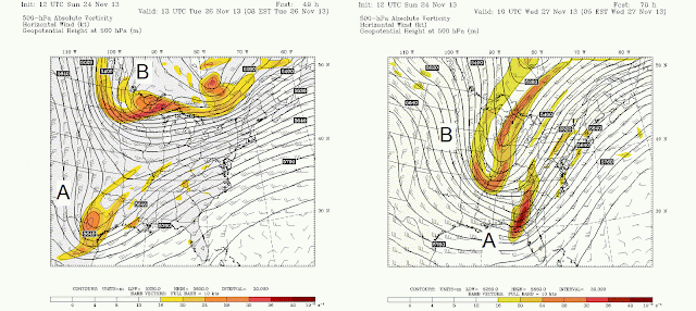
The atmospheric players responsible for this coastal storm are a cut-off low that has been aimlessly spinning around in the Southwest US for a few days that is likely to finally get a move on its eastward trek and meet up with a broader trough digging down from Canada. As discussed in previous posts, mid-latitude cyclones (i.e. non-tropical storms) get most of their strength from air above the surface. The surface low and the wind pattern around the system provide a feedback mechanism that allows the storm to get stronger, as long as the upper-level energy is still there. The weather models had (and still have as of Sunday morning) some discrepancies of when and where the two key players will be and if there will be a significant storm.

The Stony Brook University Weather Research and Forecasting (SBU-WRF) model run, while only one possible solution of what may happen, is used here to discuss the event. Looking above the surface at 500 mb or about 2 miles up, the image below shows the two key players, a vorticity maximum associated with a cutoff low moving eastward in the South (A) and the vorticity maximum associated with a trough digging southward from Canada (B). Vorticity is a measure of the spin or rotation of the air. If air at upper-levels acquires a spin it can have the effect on air below it of drawing it upwards if the spin is positive (i.e. cyclonic or counterclockwise in the Northern Hemisphere). If the two features meet near the coast then a stronger coastal low may form than would have formed  from the systems independently.

500 mb height and vorticity from the SBU-WRF for two times (8 AM EST on Tuesday on the left and 5 AM EST on Wednesday on the right). The phasing of the two vorticity maxima (A & B) will provide the energy for a strong coastal low to develop.


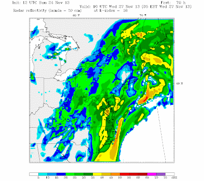
Simulated Reflectivity for 5 AM EST on Wednesday.


Let's focus our attention closer to the surface. What can we expect from this coastal system? According to our SBU-WRF simulation, there should be periods of heavy rains Tuesday-Wednesday. The image on the right shows simulated reflectivity, or what you'd expect to see if you looked at a radar image around that time. The pockets of heavier showers are indicated by the yellows, oranges, and reds. The snapshot provided is for 5 AM EST on Wednesday meaning that that broader area of precipitation north and east of LI will have already moved through on Tuesday.
925 mb Temperatures for 5 AM EST on Wednesday.

A warranted question for this event is whether that precipitation should fall as rain or snow. If we look at 925 mb temperatures, which is a little bit above the surface, LI and other coastal regions remain well above freezing for the majority of the heaviest precipitation. As the system moves to the northeast, there may be some snow showers when that colder air that is to the west moves in.

One final issue with this storm is the presence of high winds. The 925 mb image shows wind barbs at this level which indicate wind speed. The triangles symbolize 50 kts (~ 58 mph) and the longer straight line is 10 kts (~12 mph). Just south of Long Island is a wind barb showing 3 long lines, so 30 kts which is roughly 37 mph. Those winds could reach the surface if the precipitation is heavy enough, but it is likely that the strongest winds will remain off the coast of Montauk for the majority of the event. As the system intensifies, there is a chance that windy conditions can persist throughout Thanksgiving Day but at least the precipitation should have moved through by Wednesday night.


We looked at one model run of one single model to deduce this forecast. However, models are run generally about 4 times a day and there are over 5 main weather models. Each model run at each time has its own solution. For a predictable event, there isn't much difference between each time a single model is run or between different models. However, this event had started out pretty unpredictable and thus there were widely varying solutions, such as the storm occurring on Thanksgiving and LI receiving a lot of snow. To illustrate the variability, forecasters look at "spaghetti plots" which show a solution from different models for a certain atmospheric parameter. The image below shows 500 mb heights, so the green lines would show the position of that Canadian trough, or "B" in the above images. Notice how there seems to be some variability in how deep that trough is (how far it stretches southward) and even its position farther east or west.

GEFS Ensemble Solutions for 500 mb heights at 1 PM EST on Wednesday. (Source: Kyle MacRitchie)

 As time gets closer to the event and the initial atmospheric conditions that are input into the model are actually observed then the models all continue to converge on a solution. The NAM, GFS and Euro models are the main models looked at by forecasters and they are all starting to converge on a solution of a wet and windy Tuesday-Wednesday but a cool and dry Thanksgiving. Safe travels and Happy Thanksgiving!

Useful Links
- For more information about synoptic meteorology please visit The NWS Jetstream Site.
- For the latest in-house model run please visit the SBU-WRF site.
- For more spaghetti please visit Kyle MacRitchie's site.

Monday, November 18, 2013

Watching Disaster from a Distance: Typhoons and Tornadoes

The weather on Long Island has been typical for Fall; one day you need a winter coat and the next day you are tempted to throw on shorts. This is due to the steady eastward progression of storm systems from the clashing of air masses across the country. This active pattern shows that the atmosphere has a lot of energy to dispel. Recently, attention has been focused to where the weather systems have been a lot more destructive and impacted so many unfortunate people that were caught in their paths.

Super Typhoon Haiyan: A Meteorological Perspective

Super Typhoon Haiyan before landfall. (Source: UW-CIMMS)
Super Typhoon Haiyan, or Yolanda as it was locally known, wreaked havoc in the Philippines before tracking towards extreme northern Vietnam and Southern China. Tropical systems form from a preexisting disturbance, or cluster of thunderstorms. Unlike the low pressure systems that we are used to during this time of year that get their energy from the air at upper-levels, tropical systems grow from the bottom-up. The heat and moisture from a warm ocean surface is what allows for tropical systems to grow to the highly-organized devastating systems that they can be. The heat from the ocean is brought towards the center which causes the center to be warmer than the outside environment. Therefore there is lower surface pressure in the center because warmer air is less dense or less heavy than colder air. Once a surface low pressure center is acquired, the storms can rapidly intensify and acquire much more of a spin as winds travel cyclonically towards the center (which is counter-clockwise in the Northern Hemisphere). Another difference between the non-tropical cyclones that we are used to in the fall season and tropical systems is that non-tropical cyclones need to have their low pressure center titling sideways with height otherwise air can fill it in and essentially kill it. The reverse is true for tropical cyclones that require a completely vertical core to survive. Think of a chimney, for example. If you close the flue then all of that smokey air comes right into your home instead of exiting and that smokey air is not healthy for survival, just like cold and dry air is not healthy for a tropical system's survival. In the atmosphere, the wind speed and direction varying with height is called wind shear, or just shear. In order for a tropical cyclone to remain upright there needs to be very little shear.

The three greatest risks to life and property associated with tropical cyclones are high winds, a lot of rain and storm surge. Long Islanders are no stranger to storm surge from last year's Hurricane Sandy impacts. Storm surge occurs when a storm travels over open water and as you've seen when you blow on the surface of your cup of coffee, water piles up downwind. When a storm is moving in a certain direction, the water piles up in the quadrant that lines up with the way the winds are blowing. In the case of Haiyan, that was its northwest quadrant (or upper-left). The geography of the Philippines made the storm surge even more impactful because water was channeled between islands of the archipelago and the relatively flat terrain allowed the water to reach far inland.  

Typhoon Haiyan formed from a small cluster of thunderstorms and fed themselves the energy from the warm waters of the West Pacific Ocean. The system acquired rotation and was able to intensify to the highest possible classification of typhoon (Super Typhoon is similar to our Category 5 Hurricane in the Atlantic Ocean Basin). The typhoon formed over waters near or exceeding 30 C (86 F) around November 6th and tracked westward in an environment with very low shear (< 10 m/s) which allowed it to form a nearly perfectly symmetrical eye and central dense overcast (CDO) region of clouds around the time of its estimated peak intensity before its first landfall. This landfall devastated the city of Tacloban on November 8th with high winds, driving rain and a sudden and powerful storm surge estimated at greater than 15 feet with 30-foot waves estimated from satellite measurements. The landfall and associated precipitation can be seen from this radar loopLightning was found to be very prominent in the eyewall of Super Typhoon Haiyan which provides some insight into the ferocity with which winds were rising and taking a variety of raindrops and even ice very high above the storm that had a different electric charge what was within the nearby clouds.

Typhoon Haiyan left the Philippines and then made a northwestward move to extreme northern Vietnam. This was due to the steering flow in place, or the fact that a broad region of high pressure around which winds flow anticyclonically (clockwise in the Northern Hemisphere) so that once Haiyan got on its western edge, it was steered more towards the north (from 6 to 10 o'clock, for example). Although it weakened a little bit, it maintained typhoon status because the waters of the South China Sea were a very warm 26-29 C (78-85 F) and there was still very weak wind shear allowing it to keep its vertical structure in the moist environment of the region.

Super Typhoon Haiyan: A Historical Perspective

The Philippines unfortunately, like most Caribbean nations, lie right in a prominent tropical storm track. It's not unusual for them to make landfall and fortunately the strongest super typhoons do tend to stay out to sea and only affect mariners.
Source: Wikipedia
Prior to Haiyan's formation, several tropical cyclones had already crossed the Philippines this year with the more recent storm's associated rainfall causing the soil to be saturated and mudslides imminent.
Source: Brian McNoldy (UM/RSMS)

Dvorak Intensity Scale of Haiyan (Source: UW-CIMMS)
There was some discussion among the media that falsely claimed that this storm was the strongest tropical cyclone in history which isn't true. As of now there are no ground-based observations of wind speed to provide any information about the storm's actual intensity. In the Atlantic, we rely on aircraft observations of wind speed for official observational purposes that also help make the computer models of the storms more accurate. Unfortunately, there aren't usually aircraft flown into typhoons in that region of the Northwest Pacific so all of the wind speeds had been estimated from satellite imagery with what is known as the Dvorak technique. The Dvorak technique uses satellite imagery of structure, cloud top temperature and other quantities to estimate the strength of a tropical system where there is no actual observational data within the storm. Super Typhoon Haiyan did reach the highest level of 8 on the Dvorak Intensity Scale, but a lack of ground-based measurements will mean that it is unlikely that the strongest winds produced by Haiyan were measured and reported.

The rainfall from Super Typhoon Haiyan wasn't anomalously high for tropical systems traversing the Philippines, but unfortunately many tropical systems were tracking right across the archipelago in recent weeks. A tropical storm had just crossed a few days prior to Haiyan making landfall which caused a combined accumulation of about two feet of rain in ten days. Haiyan had slightly stronger rainfall rates as compared to that tropical storm, but only by about a half of an inch per hour. All rainfall measurements were derived from the TRMM satellite again due to the lack of ground-based measurements. (Source: NASA

This storm was incredibly powerful and our thoughts are with all of those affected. If you haven't already please consider donating to the relief efforts via organizations such as the Red Cross.

For more information about tropical cyclones please visit: Tropical Cyclone Introduction (NOAA/NWS) 
For more information about Typhoon Haiyan please visit the following sites:
- University of Wisconsin-Madison CIMMS Satellite Blog
- NASA's Haiyan Blog Entry

Closer to Home: Tornado Outbreak of November 17, 2013

Switching gears to a discussion about a much more recent event and one that struck a lot closer to home, today there was a fatal tornado outbreak in the Ohio Valley. A strong continental cyclone with a surface pressure at the center below 990 mb after 00 UTC on November 17th or after 7 PM local time moved from the Midwest towards the east throughout the day on Saturday and Sunday. Out ahead of its cold front, warm moist air moved northward and filled the Great Plains with that air mass that is very conducive for fueling thunderstorms.

Weather Prediction Center Surface Analysis for 00Z November 17 (7 PM EST).


As previous posts have discussed, for severe and especially tornadic storms the following ingredients are needed: moisture, instability and lift. The moisture is necessary because if dry air is lifted, clouds will not form. Instability is needed because the air being lifted needs to be able to lift itself very quickly which usually means it's warmer than the air surrounding it (think of a hot air balloon). The lifting mechanism can be the cold, dense air of an approaching cold front or if there is enough moisture and instability, a slight push from the cooler air from a neighboring thunderstorm may be enough to send the air rising violently. Another important ingredient is shear (just like as discussed regarding larger systems above). A thunderstorm that forms in an environment with a large amount of directional shear can actually have air horizontally rotating near the surface that is then bent upright by the storm's updraft that can then exhibit the same rotation and spawn tornadoes.

The models had predicted the environmental conditions conducive for a widespread severe weather outbreak in the Ohio Valley for Sunday, November 17th. The conditions verified by looking at the surface observations that morning as well as the weather balloon observations that showed plenty of moisture, sufficient low-level directional wind shear (winds from the south at the surface but trending to be more from the west with height), and the potential for instability as the sun warmed the surface throughout the mid-morning hours. The Storm Prediction Center issued a spine-tingling "Particularly Dangerous Situation" statement which they reserve for tacking onto watches that are highly probable and likely to be highly destructive to life and property. Two such PDS watches were issued today (#1 and #2). The SPC can't issue warnings as that is up to the local National Weather Service Weather Forecast Office.

Storm Reports as of 11 PM EST from NOAA/SPC.
As of 11 PM EST there have been reports of 81 tornadoes as well as over 400 reports of damage due to high winds estimated to be greater than 73 mph (65 kt). The news outlets are reporting 5 fatalities attributed to the outbreak. Hopefully that number won't increase and is likely a lot lower than it could have been without the skilled forecasting expertise exhibited with this weather event.

A question I have heard some people raise is whether or not this is normal for November. I'd argue that it is normal for November. The ingredients are all there and on average there are about 50 tornadoes per year in the month of November. If the total count of tornadoes is verified to be around 80 than it may be in the top 5 of November outbreaks from data from 1950-2010 (SPC).

U.S. Average Tornadoes by Month (Source: NCDC).

This system must continue its eastward trek and with it comes the possibility for severe weather for our area. Long Island and the Tri-State area may face some damaging wind gusts before the cold frontal passage and during it. Out ahead of the front there is a strong low-level jet, or a core of strong winds, that can actually be mixed down to the surface through the development of turbulent eddies. Think of waves crashing on the shore-- the air crashes with the ground which can send some air spiraling upwards (like waves splashing upwards) and consequently air must come downwards to fill the void and if that air exhibits a higher wind speed then that is brought to the surface as a wind gust. Another term for this is mechanical turbulence. Air with higher wind speeds can also be literally dragged down to the surface by heavy precipitation and the cold, dense air rapidly rushing downward because it is negatively buoyant (think of a failing hot air balloon!). The turbulent eddies caused by the temperature difference of air near the surface versus the faster-moving air above the surface is known is thermal turbulence.

The cold frontal passage is forecast to be somewhere between 4-7 AM EST. Our department's own operational model has it passing through starting at 3 AM and finally moving east of Montauk at 7 AM. Expect heavy rains and those gusty winds that were previously discussed.

Simulated Radar Imagery from the SBU-WRF for 5 AM on November 18th.


For more information about thunderstorms please visit this NWS Jetstream Page.

Saturday, September 7, 2013

Weekly Weather Discussion: September 6th, 2013

The weekly weather discussion at Stony Brook University reviewed the interesting weather over the past week and discussed the increased activity in the Tropics.

On Tuesday, September 3, 2013 there was a cold frontal passage that coincided with some severe thunderstorms over Eastern Long Island. There was a report of severe hail (greater than 1.00 inch in diameter) in Hampton Bays. The storms were caused by a moist and unstable air mass that was set up over Long Island. However, the unstable air needed a lifting mechanism to tap into that instability and cause the air to rapidly rise and for storms to form and that mechanism was a cold front.

A tropical storm (Gabrielle) had formed in the Atlantic but didn't last long because it moved over the mountainous island of Hispaniola which was too harsh to keep the storm going. Recall that tropical cyclones get their energy from warm, ocean waters and need to maintain their stiff vertical structure which mountains would disrupt.

If a hurricane (not just a tropical storm, of which there have been 7) does not form by September 11th, then the previous record set for latest first hurricane formation in the Atlantic will be broken. There are a couple of areas of tropical convection that may organize into a tropical storm and subsequently a hurricane with time. Of special interest is a fresh wave of convection coming off the coast of Africa. The National Hurricane Center is paying strict attention to it because the environment in which the disturbance is moving is favorable for its development. Low shear (wind speed or direction changing with height that would disrupt the storm's vertical stiffness of its center), high moisture (food for clouds) and high heat content from the warm ocean waters (drives the winds and strengthening of intensity of the storms) are all important and expected to be present in the coming week for this wave. Stay tuned!


Saturday, August 31, 2013

Weekly Weather Discussion: August 30th, 2013

          The faculty and students of the Institute for Planetary Atmospheres (ITPA) at Stony Brook University hosts a weekly weather discussion where they lead a scientific discussion of the recent past, current, and future weather. This week's discussion was led by Dr. Brian Colle and was titled, "Why has the Atlantic hurricane season been so quiet and how long will it continue?"
          Dr. Colle began his discussion by providing some statistics to put the current Atlantic hurricane season into perspective. He showed the National Oceanic and Atmospheric Administration's (NOAA) official forecast from this past May for 13-20 named storms with 11 hurricanes and 3-6 major storms. Their latest updated forecast changed a bit and called for 18 named storms with 8 hurricanes and 3 major storms. Despite the relatively “slow start” to the season they are still calling for a lot of activity. The average historical peak for tropical cyclone (TC) genesis in the North Atlantic is about the week of September 10th (NOAA/NHC), so it’s not like we already missed the expected peak period of activity. Dr. Colle discussed the quantity called accumulated cyclone energy (ACE) which measures the relative intensity of each storm by estimating the energy used by each storm (more info here). ACE can be used to compare relative intensities of storms or the relative intensity of an entire season. On a per-month basis, ACE also peaks in September in the Atlantic (from Dr. Ryan Maue’s page). Given this information, perhaps this Atlantic hurricane season shouldn’t yet be written off just yet but it looks like the date of the first hurricane formation may break records (McNoldy, CWG) for being later than previously observed. ACE on a globally integrated scale has been decreasing since 2005 (Maue 2011) but that may be a result of there being less intense storms during the later period from 2005-2012 (Maue’s page).
        What was the deal with the start of this Atlantic hurricane season? To date there have been 6 named storms, none of which reached hurricane strength. Tropical cyclones gain their energy at the surface, unlike strong winter storms that predominately gain their energy from winds at upper-levels of the atmosphere. Tropical cyclones typically start as clusters of disorganized convection (thunderstorms) that blow towards the west off of the coast of Africa. However, they can form from many other locations but those that form from African easterly waves, or the organized storms off of Africa, are the focus of this discussion. Tropical cyclones feed their energy off of warm ocean waters and there are several factors that can hurt their formation and development. They need warm ocean waters, moist air and weak vertical wind shear or strong winds from the west at upper levels when there are strong winds from the east at lower levels.
          Usually, the El Nino-Southern Oscillation (ENSO) when it is in its El Nino phase tends to contribute to a less active Atlantic hurricane season because of increased wind shear over the Atlantic. However, ENSO isn’t a major player this season because it is in its neutral phase, so Dr. Colle showed some plots to explain why the activity had been low starting on July 1st. The first point that he made was that there was anomalously dry air in the atmosphere (-12% RH anomaly) stretching westward from Africa all the way across the Atlantic into the Caribbean especially during the period  August 1st-15th. The Saharan Air Layer (SAL) which is dry, dusty air originating from the Saharan Desert provided a harsh environment for TC development and growth. In analyzing vertical stability or the resistance of the air to rise on its own, the Tropics are more stable this year compared to average conditions (McNoldy, CWG) so that would act to discourage convection. Sea surface temperature (SST) anomaly maps didn’t show too much of an explanation for why activity has been weak because the Tropical Atlantic waters are quite warm. Maps of upper-level shear anomalies did show that during the period August 1st-15th there was a 2-3 m/s westerly shear anomaly in the tropical Atlantic basin. Therefore, the weak activity was shown to be likely tied to the dry air and westerly shear that created an unfavorable environment for TC development.
          How long will this stifled activity last? Likely not long, Dr. Colle explained. Climatological shear values are back in place and the dry anomalies are starting to weaken and the atmosphere is becoming more moist. At the time of the discussion, there was an area of thunderstorms or an National Hurricane Center (NHC) invest area with a 40% probability for the chance of development that should move westward into an area with weaker shear but still some residual dry air. If it makes it past the subtropical high, according to the GFS model, it may encounter a trough that may recurve it and keep it away from the Caribbean and East Coast. We’ll see what happens. Looking beyond this one system and to the rest of the Atlantic hurricane season as a whole, most students at the discussion agreed that they were not ready to give up on the season yet. Assuming that the environment becomes more favorable for tropical cyclone development in the North Atlantic Ocean then this season's forecast for the number of storms may pan out.

For more information about tropical cyclone statistics visit the NOAA/NHC website: http://www.nhc.noaa.gov/climo/
For frequently asked questions about tropical cyclones visit the NOAA/NHC website:
http://www.nhc.noaa.gov/faq.shtml